Autel Robotics EVO II PRO Review (2026): A Spec-Based Look
This Autel Robotics EVO II Pro review analyzes 1 drones using only published specifications. We break down the 1-inch sensor, 6K video, and RTK positioning for you.
As Amazon Associates, we earn from qualifying purchases. This means we may receive a small commission at no extra cost to you if you click through and make a purchase.
As an Amazon Associate we earn from qualifying purchases. Links on this page are affiliate links.
This autel robotics evo ii pro review covers the Autel EVO II Pro RTK V3, a drone built for high-precision mapping and inspection. It features a 1-inch sensor capable of shooting 6K video at 30fps HDR. The standout addition is the integrated RTK module, which delivers real-time centimeter-level positioning accuracy. This hardware allows for stable data acquisition in complex environments without needing ground control points. You get a 38-minute flight time and a transmission range of up to 15 kilometers. The drone supports autonomous waypoint missions and replicates gimbal movements for consistent results. It is FAA Remote ID compliant and designed for professional field use.
- RTK module with 1 cm horizontal positioning accuracy
- 1-inch sensor recording 6K/30fps HDR video
- 38-minute maximum flight time
- 15-kilometer transmission range
- Autonomous mission execution with gimbal replication
Good fit for
This drone suits surveyors, power inspectors, and emergency response teams who need precise geotagged data. The RTK integration eliminates the need for ground control points, streamlining workflows for mapping and orthoimage creation. If you require repeatable flight paths for fire inspection or environmental monitoring, the waypoint and polygon task features ensure consistent coverage. The 15-kilometer range helps cover large sites efficiently. Professionals using software like Carlson PhotoCapture will find the data output compatible with their existing pipelines for CAD plans and point clouds.
Who can skip it
You should look at another option if you prioritize casual photography or social media content. The 6K/30fps limit may feel restrictive compared to drones offering higher frame rates for slow-motion video. The focus on RTK precision and autonomous mapping missions means this unit is specialized rather than versatile for general hobby flying. If you need a smaller footprint, note that the drone measures 21 inches in length. Users seeking simple, plug-and-play recreational flying might find the technical requirements for RTK base stations and ground control unnecessary for their needs.
Verdict
The Autel EVO II Pro RTK V3 is a specialized tool for professionals requiring centimeter-level accuracy and long-range mapping capabilities. Its RTK integration and 1-inch sensor make it ideal for surveying, inspection, and data acquisition tasks.
Key specs explained
Flight Time 38 min
This drone stays airborne for 38 minutes on a single charge. You get more time to survey large areas or complete complex inspection routes without landing to swap batteries. This duration is useful for mapping projects where covering ground efficiently matters. Compare this to standard models that often offer around 30 minutes. The extra flight time reduces downtime and helps you finish missions faster.
Sensor Size 1''
The camera uses a 1-inch sensor, which is larger than the small sensors found in many entry-level drones. A larger sensor captures more light, resulting in cleaner images and better performance in low-light conditions. You will notice less noise in your photos and smoother video quality. This spec is ideal for users who need high-quality aerial imagery for professional documentation or detailed visual analysis.
Video Resolution 6K/30fps HDR
You can record video at 6K resolution with High Dynamic Range at 30 frames per second. This high resolution allows you to crop into the footage later while still maintaining sharp detail. HDR helps balance bright skies and dark shadows in the same shot. This combination is beneficial for creators who need maximum flexibility during post-production and want professional-grade visual quality.
Transmission Range 15KM
The control link extends up to 15 kilometers, allowing you to fly farther from your starting point. This range gives you confidence when operating in open spaces or conducting wide-area surveys. You maintain a stable connection even at significant distances. This spec is important for users who need to cover large territories or inspect distant infrastructure without losing signal control or video feed.
Design and build overview
The Autel EVO II Pro RTK V3 measures 21 inches in length, 5.5 inches in width, and 17.8 inches in height. These dimensions define its physical footprint when folded or in flight mode. The listing describes the color as orange. This specific finish helps you spot the drone against green foliage or gray urban backgrounds. You can identify the aircraft quickly from a distance, which matters during search and rescue or law enforcement operations.
According to the listing, the drone integrates an entirely new RTK module. This internal hardware provides real-time centimeter-level positioning data. You do not need to attach external ground control points. The system supports both RTK base station and RTK network modes. This flexibility allows you to operate in complex environments where network coverage might be limited. The drone remains FAA Remote ID compliant, ensuring you meet standard regulatory requirements for unmanned aircraft systems.
The physical layout supports mission execution with advanced intelligence. You can create waypoint, rectangle, polygon, or oblique photography tasks. The drone flies the designated path autonomously. It records previous shooting positions and replicates gimbal movements. This repeatability ensures consistent data acquisition for mapping and inspection. The durable build handles various fields, from power inspection to environmental protection. You rely on the stable frame to maintain accuracy during these specialized tasks.
Setup and everyday use
Setting up the Autel EVO II Pro RTK V3 requires attention to both the drone and your computer. The drone supports RTK base stations and RTK networks for real-time centimeter-level positioning. You must configure the GNSS settings to match your mission requirements. For mapping tasks, you will need to use the Autel Mapper software on a compatible PC. The listing specifies that your computer must run Windows 10 or 11 64-bit. It also requires an NVIDIA graphics card with computing power of 3.0 or higher. The driver version must be 471.11 or later. This ensures smooth processing of point clouds and orthoimages.
In everyday use, the drone executes autonomous flights via waypoint, rectangle, polygon, or oblique photography tasks. The RTK module provides 1 cm plus 1 ppm horizontal accuracy. This allows you to record previous shooting positions. The gimbal and camera movements replicate exactly on repeat missions. You do not need ground control points for these tasks. The system supports PPK and time synchronization. This flexibility helps in complex environments like firefighting or power inspection. The 15 km transmission range keeps your connection stable during long flights. The 38-minute flight time lets you cover large areas efficiently. You can create surfaces and CAD plans directly from the collected data. The drone is FAA Remote ID compliant. This setup supports professional workflows in mapping, law enforcement, and environmental protection.
Before You Buy This Drone
Owning the Autel EVO II Pro RTK V3 requires specific preparation. You need a computer running Windows 10 or 11, paired with an NVIDIA graphics card of compute capability 3.0 or higher and driver version 471.11 or later. This setup is essential for using Autel Mapper software effectively. The drone supports RTK base stations and networks, so you must ensure your ground control infrastructure matches these requirements. Regular firmware updates are necessary to maintain the centimeter-level positioning accuracy. Unlike standard consumer drones, this unit is built for professional mapping and inspection tasks. It fits alongside other high-end options in Drones & Action Cameras by offering specialized RTK capabilities. You should also consider the FAA Remote ID compliance for legal operation. Proper maintenance of the gimbal and sensors ensures long-term reliability. This drone is not for casual flying but for precise data acquisition.
Check before you buy
- Verify your computer has an NVIDIA GPU with compute capability 3.0 or higher
- Confirm you have an RTK base station or network access for positioning
- Check that your operating system is Windows 10 or 11 64-bit
- Ensure your graphics driver is version 471.11 or later for Autel Mapper
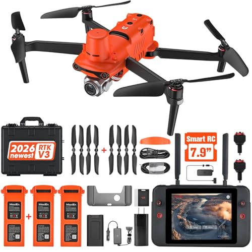
Autel EVO II Pro RTK V3
Best for: professional mapping and surveying missions
- Video Resolution
- 6K/30fps HDR
- Sensor Size
- 1''
- Flight Time
- 38 min
- Transmission Range
- 15KM
- Dimensions
- 21 × 5.5 × 17.8 inches
The Autel EVO II Pro RTK V3 is a professional mapping drone featuring a 1-inch sensor and 6K/30fps HDR video capability. It includes a 38-minute flight time and 15km transmission range. The unit integrates an RTK module for centimeter-level positioning accuracy, supporting real-time base stations and networks. This system allows for precise autonomous missions without ground control points, making it suitable for detailed surveying and inspection tasks.
- 1-inch sensor captures 6K/30fps HDR video
- 38-minute maximum flight time
- 15km transmission range
- Real-time centimeter-level RTK positioning
- Supports autonomous waypoint and polygon missions
- Large dimensions measuring 21 inches in length
- Requires Windows 10/11 with specific NVIDIA graphics card for Autel Mapper software
- Orange color option only
- You need centimeter-level positioning accuracy for mapping
- You require long-range transmission for surveying
- You want extended flight time for large areas
- You need a compact drone for travel
- You lack a high-performance NVIDIA graphics card
- You prefer standard consumer photography specs
Verdict: Autel EVO II Pro RTK V3 Drone is ideal for professionals requiring precise RTK data and high-resolution imaging for large-scale mapping projects, provided you have the necessary computer hardware for post-processing.
Specifications side by side
| Spec | Autel EVO II Pro RTK V3 |
|---|---|
| Video Resolution | 6K/30fps HDR |
| Sensor Size | 1'' |
| Flight Time | 38 min |
| Transmission Range | 15KM |
| Dimensions | 21 × 5.5 × 17.8 inches |
| Color | Orange |
Frequently asked questions
What video resolution does the Autel EVO II Pro RTK V3 capture?
It records 6K video. This high resolution provides detailed imagery for mapping and inspection tasks. You can shoot at 30fps with HDR support. This spec ensures you have enough pixel data for post-processing large-scale projects.
Is this drone suitable for professional surveying?
Yes, it is built for professional mapping and surveying missions. The integrated RTK module delivers precise positioning data. This feature is critical for tasks requiring centimeter-level accuracy. It supports RTK base stations and networks for real-time corrections.
What are the physical dimensions of the Autel EVO II Pro RTK V3?
The drone measures 21 inches in length, 5.5 inches in width, and 17.8 inches in height. These dimensions define its footprint during flight and storage. The listing identifies the color as orange. These measurements help you plan transport and storage.
Do I need a specific computer to use the RTK features?
You need a computer running Windows 10 or 11. It must have an NVIDIA graphics card with compute capability 3.0 or higher. The driver version must be 471.11 or later. This hardware is essential for processing the high-resolution data.
How does the RTK module improve flight performance?
The RTK module provides real-time centimeter-level positioning. It allows you to configure GNSS settings to match your mission requirements. This precision is vital for large-scale mapping where accurate geotagging is necessary for the final output.
What is the best use case for this drone?
It is ideal for professionals requiring precise RTK data. You should use it for high-resolution imaging in large-scale mapping projects. The 6K sensor captures detailed visuals. Ensure you have the necessary computer hardware for effective post-processing of the collected data.


